


Description
Product Overview
The Kids Earth Atlas from Phillips is a meticulously crafted digital atlas designed specifically for young explorers aged 11 to 14. Delivered as a Kindle eBook, the title spans 89 pages of high‑resolution cartographic content, each page optimized with enhanced typesetting to ensure crisp text and clear graphics on any screen size. The file size of 115.3 MB provides ample space for richly detailed maps, interactive features, and supplemental multimedia that bring continents, oceans, and geological phenomena to life. Accessibility is a core focus: the atlas supports screen readers, includes Word Wise for vocabulary assistance, and offers Page Flip for a realistic page‑turning experience. Publication details confirm a recent release date of September 5 2024, ensuring that the geographic data reflects the latest political boundaries and scientific understanding. The ISBN‑13 978‑1849076845 guarantees authenticity, while the ASIN B0CW1GS6DM makes it easy to locate within the Kindle Store. With a customer rating of 4.8 stars from 17 reviews, readers consistently praise the clear layout, engaging visuals, and educational value of this atlas.
![[Product front view showing all components]](https://www.healthyfamily.store/wp-content/uploads/2026/06/996ae0365a4a4733b6fe882d407df689.jpg)
Usage
Designed for both classroom and home environments, the Kids Earth Atlas serves as an ideal companion for geography lessons, science projects, and independent study. Teachers can assign interactive map activities that align with curriculum standards, allowing students to explore physical features, climate zones, and cultural regions without leaving their desks. Homeschooling families benefit from the on‑demand access, enabling flexible lesson pacing and the ability to revisit specific sections as needed. The lightweight digital format makes it perfect for travel; whether on a family road trip, a school field excursion, or a summer camp, the atlas can be accessed on any Kindle device or compatible tablet, providing instant reference material without the bulk of a traditional hardcover. The Word Wise feature assists emerging readers in mastering new terminology, while the screen‑reader compatibility ensures that visually impaired students can fully participate in geographic exploration. Overall, the atlas supports a wide range of learning styles, from visual learners who appreciate vivid illustrations to auditory learners who rely on narrated content.
Why Choose Us
Phillips has a long‑standing reputation for publishing educational resources that combine scholarly accuracy with engaging presentation. This atlas reflects that commitment through rigorous fact‑checking, up‑to‑date geopolitical information, and a design philosophy that prioritizes user experience. The enhanced typesetting and high‑resolution graphics are the result of a dedicated production team that works closely with cartographers, educators, and accessibility experts. By choosing this product, customers receive a resource that not only meets academic standards but also exceeds expectations for interactivity and inclusivity. The Kindle platform ensures automatic updates, so any future revisions to maps or data can be delivered seamlessly to the reader’s device. Additionally, Phillips offers responsive customer support, ready to assist with technical questions, usage tips, or educational guidance. This after‑sales service reinforces the brand’s dedication to long‑term satisfaction and educational success.
Key Features
- Interactive maps that let students zoom, tap, and explore geographic details with a single touch.
- Enhanced typesetting ensures legible text and vibrant images on all Kindle devices.
- Word Wise support helps young readers build vocabulary while navigating complex terms.
- Screen‑reader compatibility provides an inclusive learning experience for visually impaired users.
- Dedicated customer support offers guidance and troubleshooting for educators and families.
FAQ
What devices can I use to read the Kids Earth Atlas?
The atlas is compatible with all Kindle e‑readers, Kindle Fire tablets, and any device that runs the Kindle app, including iOS, Android, and PC/Mac computers.
Is the content updated to reflect recent geopolitical changes?
Yes. The atlas was published in September 2024 and includes the latest country borders, capital cities, and major geographic updates. Future updates will be delivered automatically through the Kindle platform.
Can the atlas be used for classroom assignments?
Absolutely. Teachers can assign specific chapters, create interactive quizzes using the map features, and integrate the atlas into lesson plans for geography, earth science, and social studies.
Does the atlas support accessibility features?
Yes. It includes screen‑reader support, Word Wise for vocabulary assistance, and enhanced typesetting that improves readability for all users.
What kind of customer support does Phillips provide?
Phillips offers email and live‑chat support for technical issues, educational inquiries, and general assistance. The support team is available during standard business hours and strives to respond within 24 hours.






 Kids World Atlas Kindle Edition by Amazon with 140 Page Map Book
 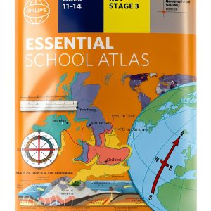 Kids Earth Atlas by Phillips Kindle Edition for Ages 11 to 14
  Saga della Serenella Book 1 - Italian Kindle Fiction Navicelli
  Children's Atlas by Tordwifel Books Kindle eBook 912 Page Map
  Spanish Children Atlas Nórdica Libros Kindle eBook 244‑Page Map
  Children's Atlas by DK Children 66‑Page Illustrated World Map for 9‑12
  DK Children Kids Atlas for Ages 9-12 – 66 Page Kindle Edition
  Historical Fiction eBook EINAUDI Italian Kindle Enhanced Typesetting
  Pennsylvania Kids Travel Guide Interactive Kindle Atlas by Amazon
  Mussolini Historical Fiction Kindle eBook by Bompiani – Italian Novel
  Kingsbridge Historical Thriller Kindle eBook by MONDADORI – Italian
  Children's Atlas duopress Kindle eBook Ages 2+ Guided View 16 Pages
  Historical Fiction eBook by Marsilio Italian Kindle Edition 149 Pages
  Children's Press Learn About Kids Atlas Kindle eBook for Ages 5‑7
  Kids World Atlas by DK Children Interactive Maps for Ages 6 to 10
  BBC Children Atlas Interactive World Map for Ages 8 to 17
  DK Children Kids Atlas Ages 9‑12 – Illustrated Kindle eBook
  DK Children Kids Atlas for Grades 4-7 66 Page Illustrated Geography
Reviews
There are no reviews yet.